
|
|
|
Travelers Look At Australia Map 1988
By National Geographic
|
|
|
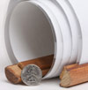
What are rails?
The type of Rails available for this map are wooden dowels that connect to the top and the bottom of the map to help it hang flat against the wall.
The top rail has a thin rope that can hang from a hook or nail.
The bottom rail has a thin rope used to pull the map down.
These rails serve as a hanging option that eliminates the need for tape or pushpins. | 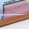
 | | (click on the images for a closer view) |
|
|
|
|
Product Highlights |
|
Travelers Look At Australia Map 1988 |
|
Item#:
X NGC 021988a |
|
National Geographic celebrated Australia's bicentennial with a whole issue devoted to the continent in February 1988. This infomative physical map features an abundance of information about the history, climate, and tourist activities to be found "Down Under." A wonderful companion to the map of "Australia's Continental Odyssey" published in the same issue. The 1988 "A Traveler's Look at Australia" map features:
• Information about each region including major cities, history, climate, and industry
• Tourist information and attractions such as skiing, coral reefs, big-game fishing, Aboriginal rock art, riverboat cruises, wine regions, and more
• Mining areas and gemstone deposits
• Aboriginal land claims and parks/reserves
• Major roads, railroads, and selected airports
• Historical information including the routes of explorers
• Ferry routes
Coverage Area: Australia
|
|
 |
More Product Details
This map requires 7 business days to print and laminate prior to shipping.
Appearing in the February 1988 issue of the National Geographic Magazine, this Travelers Look At Australia map has been reproduced from its original cartography in order to bring to life a beautiful poster previously only seen in National Geographic Magazine. This reproduction holds true to the high standards that National Geographic Maps are known for.
Perfect for home, office or classroom, this map also makes a great gift. Map collectors will surely want to add this map to their library.
The Paper version is printed on high quaility semi-gloss paper, perfect for framing.
The Laminated version uses 3mm laminate on both sides for durability, is easy to clean and markable.
From the National Geographic Classic Maps collection, this reproduction is just one of hundreds of titles available here. These maps are Printed on Demand. Sizes are approximate and may vary due to the nature of the trimming and laminating processes.
|
|
Shipping Conditions
Maps.com ships only to US & Canada
 | This product can only be shipped to the Domestic U.S.A. (No APO's or PO Boxes) |  | This map requires 2 business days to print and laminate prior to shipping. |
|
|
|
Best Seller ranking based
on customer purchases.
|
|