
|
|
|
World Ocean Floors, Arctic Ocean Map 1990
By National Geographic
|
|
|
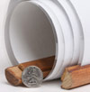
What are rails?
The type of Rails available for this map are wooden dowels that connect to the top and the bottom of the map to help it hang flat against the wall.
The top rail has a thin rope that can hang from a hook or nail.
The bottom rail has a thin rope used to pull the map down.
These rails serve as a hanging option that eliminates the need for tape or pushpins. | 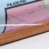
 | | (click on the images for a closer view) |
|
|
|
|
Product Highlights |
|
World Ocean Floors, Arctic Ocean Map 1990 |
|
Item#:
X NGC 011990a |
|
Experience the breathtaking detail of the Arctic Ocean floor with this fascinating map. Published in January 1990, nearly a year after the Exxon Valdez spilled an estimated 11 to 30 million U.S. gallons of crude oil into Prince William Sound, this striking map accompanied the article "Alaskas Big Spill - Can the Wilderness Heal" and an additional map of the Atlantic Ocean floor. Included on this map is the article "Exploring and Mapping the Seafloor" which explains the technology behind this amazing cartography. The 1990 World Ocean Floors, Arctic Ocean map features:
• Article entitled "Exploring and Mapping the Seafloor " by Rear Admiral Richard F. Pittenger, Oceanographer of the Navy
• Inset of the earths plates as seen from the North Pole
• Illustrations of and text about continental margins, trenches, seamounts, abyssal plains, ridges, and the ocean crust
• Striking detail of the Arctic floor including continental shelves, basins, plains, plateaus, fracture zones, and more
• Digital image sample
• Ocean depths
Coverage Area: Arctic Ocean
|
|
 |
More Product Details
This map requires 7 business days to print and laminate prior to shipping.
Appearing in the January 1990 issue of the National Geographic Magazine, this World Ocean Floors, Arctic Ocean map has been reproduced from its original cartography in order to bring to life a beautiful poster previously only seen in National Geographic Magazine. This reproduction holds true to the high standards that National Geographic Maps are known for.
The Paper version is printed on high quaility semi-gloss paper, perfect for framing.
The Laminated version uses 3mm laminate on both sides for durability, is easy to clean and markable.
From the National Geographic Classic Maps collection, this reproduction is just one of hundreds of titles available here. These maps are Printed on Demand. Sizes are approximate and may vary due to the nature of the trimming and laminating processes.
|
|
Shipping Conditions
Maps.com ships only to US & Canada
 | This product can only be shipped to the Domestic U.S.A. (No APO's or PO Boxes) |  | This map requires 2 business days to print and laminate prior to shipping. |
|
|
|
Best Seller ranking based
on customer purchases.
|
|