
|
|
|
Classic USA Wall Map
By GeoNova Publishing, Inc.
|
|
|
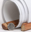
What are rails?
The type of Rails available for this map are wooden dowels that connect to the top and the bottom of the map to help it hang flat against the wall.
The top rail has a thin rope that can hang from a hook or nail.
The bottom rail has a thin rope used to pull the map down.
These rails serve as a hanging option that eliminates the need for tape or pushpins. | 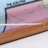
 | | (click on the images for a closer view) |
|
|
|
|
Product Highlights |
|
Classic USA Wall Map |
|
Item#:
MDC1 GN US CLA |
|
Perfect for home, business or education, this Classic USA Wall Map is a political map of the United States, presented in a warm, traditional color palette. Special features include shaded relief, ivory colored oceans, and a black decorative border. This map of the USA uses the Albers Equal Area projection. Detail included on this Wall Map of the United States:
• Time Zones
• Major Physical Features
• Primary Highways and Freeways
• Major Mountain Peaks
• State Boundaries
• State Capitals
• Major Cities and Urban Areas
• Shaded Relief
• National Parks and State Parks
Insets: Alaska and Hawaii
|
|
 |
More Product Details
From the Print on Demand collection, this map requires 7 business days to print and laminate prior to shipping. Sizes are approximate and may vary due to the nature of the trimming and laminating processes.
GeoNova Publishing creates exciting travel and reference maps. Combining superior digital cartography with innovative features and formats, this USA map is great for home, office or classroom use. Also available from GeoNova Publishing are beautifully detailed wall maps of the World, Continents, US States and US Cities.
|
|
Shipping Conditions
Maps.com ships only to US & Canada
 | This product can only be shipped to the Domestic U.S.A. (No APO's or PO Boxes) |  | This map requires 2 business days to print and laminate prior to shipping. |
|
|
|
Best Seller ranking based
on customer purchases.
|
|