
|
|
|
USA New Century Map
By Maps.com
|
|
|
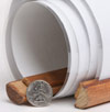
What are rails?
The type of Rails available for this map are wooden dowels that connect to the top and the bottom of the map to help it hang flat against the wall.
The top rail has a thin rope that can hang from a hook or nail.
The bottom rail has a thin rope used to pull the map down.
These rails serve as a hanging option that eliminates the need for tape or pushpins. | 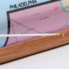
 | | (click on the images for a closer view) |
|
|
|
|
Product Highlights |
|
USA New Century Map |
|
Item#:
MDC NEW CENTURY USA MAP |
Maps.com's new United States of America New Century Map is a completely up-to-date USA map. Rich in color and décor, this map utilizes a color palette not often seen in modern mapping.
An abundance of detail combined with alluring graphics, make it suitable for use in business, education, reference or home use.
This USA wall map includes:
• US State Capitals & State primary cities
• States & International Borders & primary cities
• Secondary, and some tertiary Cities
• Oceans, Major Lakes & Rivers
• Longitude/Latitude Graticule
• Time zone boundaries
• Insets of Alaska and Hawaii
Choose your output option:
Choose from paper, laminated, or our exclusive Wallzilla format.
|
|
 |
More Product Details
Find it all at Maps.com's Map & Travel Store! We offer the biggest selection of Wall Maps, Digital & Electronic Maps, Travel Maps and Travel Guides, Globes, Atlases, Gift Ideas and more. Easy online ordering, fast shipping and quality products- Maps.com is your online Map & Travel Resource. Need Assistance finding the perfect map? Call us at 1-800-430-7532.
|
|
Shipping Conditions
Maps.com ships only to US & Canada
 | This product can only be shipped to the Domestic U.S.A. (No APO's or PO Boxes) |  | This map requires 2 business days to print and laminate prior to shipping. |
|
|
|
Best Seller ranking based
on customer purchases.
|
|